
The program envisages to improve mechanisms for cooperation on water resources management and development in the Nile Basin. In this perspective, the general scope of the present web platform is to promote the cooperation among Eastern Nile (EN) riparian countries by focusing on providing Water Resources Planning (WRP) models and tools, data and information packages, knowledge products, and services to WRP and management activities in the EN sub-basins.
IMPORTANT NOTE: All the datasets collected which were used for the water resources models implementation are mainly secondary data, either gathered by ENTRO, or taken from global datasets, publicly available; the fundamental datasets used in the project were not directly received by ministries in the beneficiary countries.
EN-Water Resources Models and Tools
EN-Hydrological and Hydraulic Models
The EN–Hydrological and Hydraulic Models group comprises tools designed to simulate key aspects of the hydrological cycle and river hydraulics within the Eastern Nile Basin. These tools support flood forecasting, watershed-scale hydrologic simulations, and river system hydraulics modeling. They help users evaluate water flow dynamics and infrastructure performance across various spatial and temporal scales.


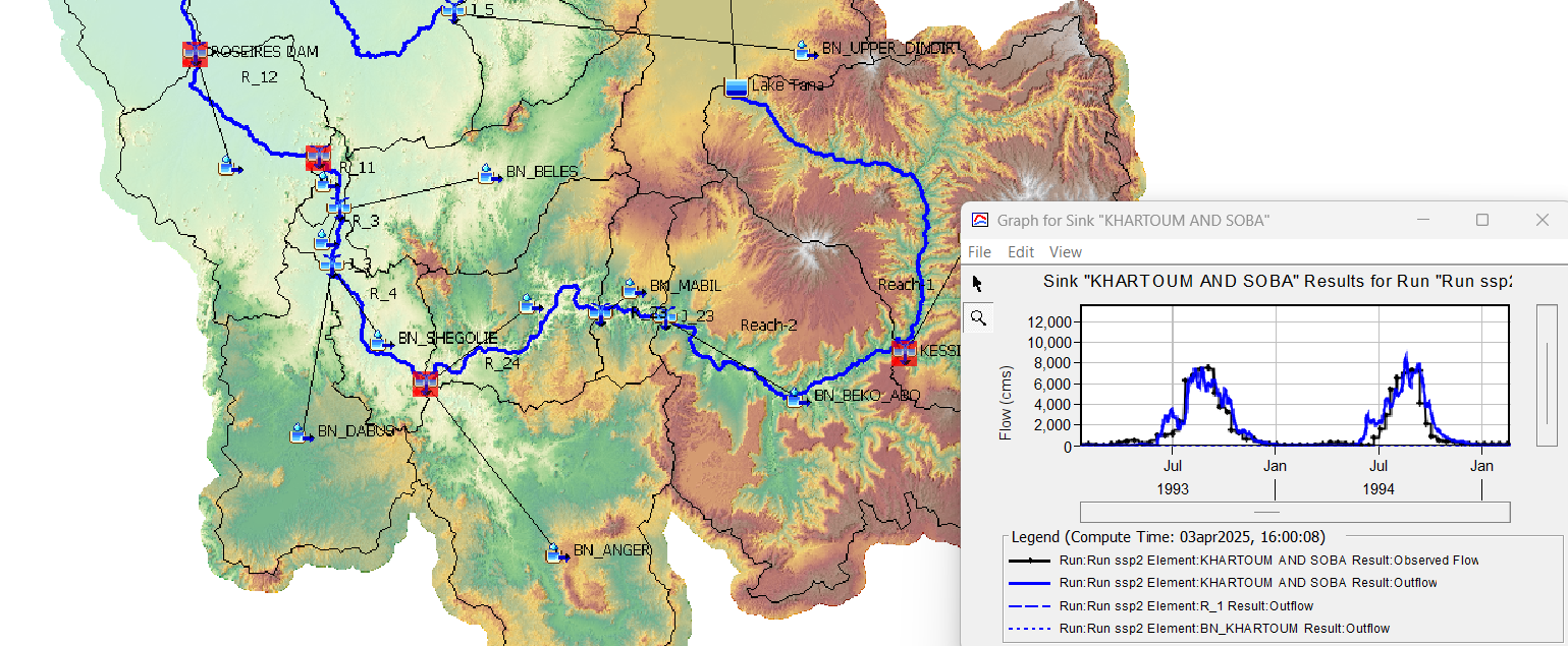
EN-Water Resources Planning Models
This model group supports the planning and management of water resources infrastructure, particularly multipurpose reservoir systems. It provides capabilities to simulate and analyze reservoir operations under varying hydrological, operational, and policy conditions, enabling users to assess alternative water management strategies.

EN-Sediments & Erosion Transport Models
The Sediments and Erosion Transport Models group focuses on evaluating soil erosion, sediment yield, and transport across watersheds in the EN Basin. These models are essential for understanding land degradation, assessing sediment-related impacts on water resources infrastructure, and supporting sustainable watershed planning.


EN-Toolkits
The EN-Toolkits subsystem incorporates a variety of data modeling, data analytics and visualization toolkits. It aims to provide users with broader insight on the existing and proposed water resources within the EN basin. Furthermore, these tools aim to support the development and scientific studies of the river basin. It is organized by dividing the whole EN Basin into its member countries/states, sub-basins as well as specific geographic locations/point datasets. Since most of these tools are replicated from ENTRO project internship programs, data might be inconsistent/incomplete. Users are advised to investigate/cross-check against other sources.


